RECORD SEARCHES AND DATA
Every year the Archaeological Research Center (ARC) staff conducts hundreds of record searches for clients. These searches are done largely for the purposes of assisting clients with meeting their obligations under Section 106 of the National Historic Preservation Act of 1966 (as amended). As part of that process, the South Dakota State Historic Preservation Office (SHPO) uses the information provided by a record search as part of their review of any project. This search generally means a review of archaeological sites, historic buildings and structures, and previous investigations known to be located in and within a one-mile buffer of the project boundaries. As a result of the search, the SHPO expects a map of known sites, surveys, and historic structures within the buffered area and a letter that contains a list of what was found as a result of the record search (including, if applicable, eligibility status with respect to the National Register of Historic Places).
Record searches can be done in several ways:
Consultants/archaeologists who are licensed to use ARMS (Archaeological Records Management System) data may conduct a record search at the Center themselves by using the in-house GIS database and the available site records, reports, and other records.A consultant/archaeologist can be hired to conduct a record search at the Center. A list of consultants/archaeologists is available on the South Dakota State Historical Society website.
A record search can also be conducted by ARC staff. This is a fee-based system. For individuals with an institutional or individual ARMS account, $75, minimum, for the first hour or any part thereof; $60 for each additional hour or any part thereof. Record searches for institutions or individuals without an ARMS account, $100, minimum, for the first hour or any part thereof; $75 for each additional hour or any part thereof. Additional information on our fee structure is available on the Resources page.
What we need
In order to carry out a record search as quickly and as efficiently as possible, we need the following:
Name and title of the individual requesting the record search, along with the name of the company they are affiliated with, if applicable
Billing address, email, and phone number of the individual/company requesting the record search
The name of the project for which the record search is being conducted and a description of the proposed project, including expected ground disturbance and/or visual impact. For example, fiber optic or water line placement; cell tower location, road widening, etc.
Location of the project; specifically, this means the county and legal location. The legal location consists of the township, range, section, and quarter section designations of the project. A street address or lot numbers are not acceptable; we lack the ability to look these up in our database.
The size of the search buffer around the project. The customary record search buffer is the area within one mile of the project. There is occasional need for a 1.5-mile buffer for historic properties where exceptionally tall cell phone towers will be placed. There is also, on occasion, a request by a Tribal Historic Preservation Office for a 3-mile buffer record search. If that should be the case, the Center will also require the name of the tribe and the Tribal Historic Preservation Officer making the request. Additionally, if the project is on tribal land, please provide your tribal permit number.
A map of the project, preferably on a 1:24,000-scale USGS quadrangle map, or a GIS shapefile of the project. Requests for large block areas will not be accepted. The greater the clarity of information provided to us, the faster we can return the information you require, and at less cost.
In order to complete your request, please download and complete the Record Search Request form and either email it to us at RecordSearch@state.sd.us or mail it back to us at:
South Dakota State Historical Society
Archaeological Research Center
PO Box 1257
Rapid City SD 57709-1257
Attention: Records Manager
The new Citizen Portal is now live. For those needing ARC staff to conduct a Record Search, the request form and payment submission can be accessed here.
What we provide
The ARC will supply the following products upon the completion of a record search request:
- - Map(s) of the project area and buffer showing sites, surveys, and historic properties. If the client is requesting a response by email, the map(s) will be in .jpg format; if by mail, they will be printed. If a shapefile of the project was submitted with the record search request, the requestor will receive shapefiles of sites, surveys, and historic structures in return rather than maps
- - A table listing the archaeological site numbers and National Register eligiblity for each site
- - A table listing historic structures; it will include the SHPO number and National Register eligibility for each property
- - A table listing previous archaeological surveys; it will contain our archive number, authors, year, and title
Example Maps
Good Map
USGS 7.5' quadrangle map at a scale of 1:24000 with the work location and work order number (if applicable) clearly indicated.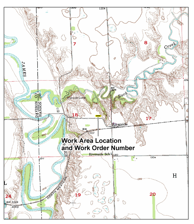
Marginal Map
Map with minimal detail. Record search requests with maps such as this may cause undue delays if ARC staff have difficulty interpreting them.
Cluttered Map
Map with too much detail, making it difficult to see where the project area is. Record search requests with maps such as this may face delays while the ARC checks back for better information.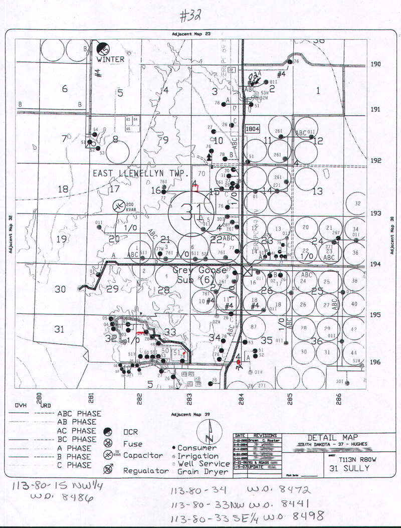
Mystery Map
An entire USGS 7.5' quadrangle map reduced to fit on a single letter-size page. Can you find the location of the work area? Neither can we!
Turn-Around Time
Record searches are done on a first-come, first-served basis. The staff tries very hard to complete record searches within one week of receipt. However, if a search area is very large or there are many searches waiting to be done, the search may take longer.
Confidentiality
South Dakota state law provides for the confidentiality of certain data pertaining to archaeological sites and conditions under which that information might be released. The data supplied in a record search conforms to that legislation:
"Confidentiality of records pertaining to location of archaeological site--Exceptions. Any records maintained pursuant to § 1-20-21 pertaining to the location of an archaeological site shall remain confidential to protect the integrity of the archaeological site. The state archaeologist may make the information from the records of an archeological site available to any agency of state government and any political subdivision of the state or to any tribe, which, in the opinion of the state archaeologist, may conduct an activity that affects any such site. The state archaeologist shall also make the information from the records of an archeological site available to the owner of the land that is an archeological site and may make the information available to any qualified researcher or research entity [SDCL 1-20-21.2]"
In other words, the information supplied in the record search is given on a need-to-know basis for the purposes of providing required information to meet the requirements of Section 106 of the National Historic Preservation Act. It is to be considered confidential and is not to be disseminated to other parties.
Data Restrictions
Shapefiles and other data are supplied on a need-to-know basis within the limitations cited above in SDCL 1-20-21.2. The Archaeological Research Center will not supply data for large tracts of property not authorized by its statutory mandate.